One of my favorite family photographs[1] is of Friedrich Hermann Schütze (1851-1909), my great-grandfather. In the photograph he looks so intense, yet contemplative; a young man who knows where he’s going in life and has the ability and ambition to get there. (As it turned out, the “there” was America.)
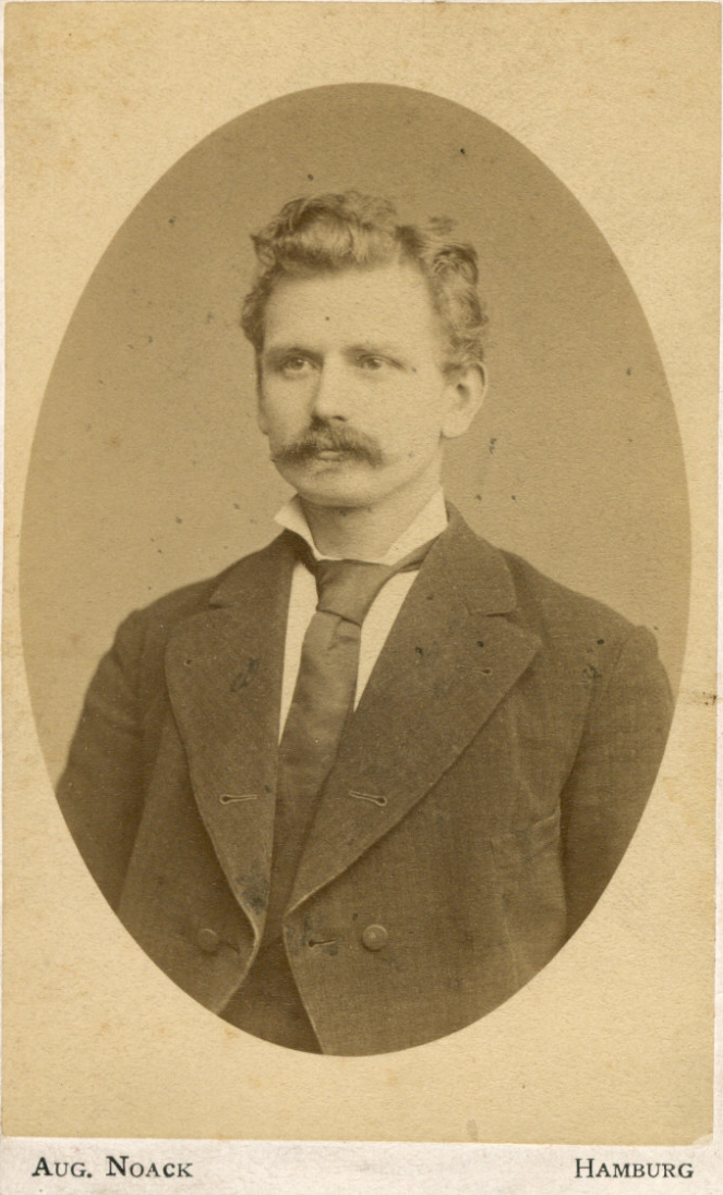
The bottom of the photograph shows it was taken in Hamburg, Germany. Since I’m going there this summer to walk in the footsteps of our ancestors, I thought it would be nice to visit the place where this picture was taken. And thus began a journey of another sort … an exploration in time and space.
The starting point of this exploration was the back of the cardboard-mounted photograph, which had a note written by my father, Leonard, as to the subject of the photo. Equally helpful, the name and address of the photo studio was imprinted there. Should be easy to find the place, right?
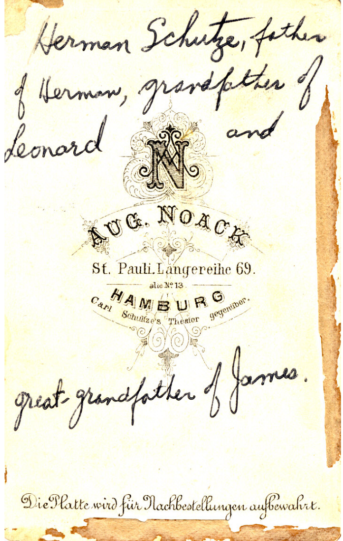
Well, sort of. Except, where the heck is “St. Pauli. Langereihe 69” in Hamburg?
Modern-day maps don’t show a Langereihe street in the St. Pauli district. That’s to be expected — the city has evolved over the 140-odd years since the picture was taken. But perhaps there’s another clue on the back? How about the phrase “Carl Schultze’s Theater gegenübuer”?
Gegenüber means “across from,” so we needed to find the Carl Schultze theater in the St. Pauli district. And here’s where an 1890 and a 1911 map of the city[2] came to our rescue.
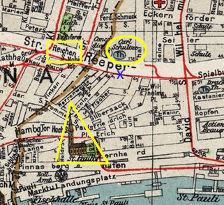
Aha, we found the place, on the south side of the current-day Reeperbahn, between Lincoln and Silbersack streets. (The original 3-story building, of which the studio was on the second floor, is long gone, unfortunately. So is the theater across the street.)
That’s the Where … How About the When?
But wait … there’s more. We wanted to confirm the location using the Hamburg city address books,[3] and sure enough, the street listings match what we found on the old map. But surprisingly, the address books also hinted at the time that the photograph was taken. The 1879 book[4] shows Aug. Noack as located at Langereihe 13, and the 1880[5] book shows him at Langereihe 69. That explains the “alte No. 13” line on the back of the photograph: formerly at Langereihe No. 13. And since Noack moved in 1879 (to show up at the new address in the 1880 book), the photograph was likely taken that year. My speculation is that the photo was taken around the time of Hermann’s wedding, July 4th, 1879. However, the photo could also have been taken as late as the spring of 1880, prior to Hermann’s departure for America on the 19th of May, as a keepsake for his new wife until she could join him three months later in Detroit. At any rate, it was taken when he was 28 or 29 years old.
So, finding the “where” of the photo also fortuitously led to finding the “when.”
And the icing on the cake?
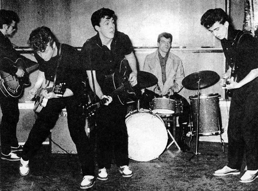
The Reeperbahn is Hamburg’s nightlife and red light district, going back at least a couple of hundred years, due to Hamburg’s function as a port city catering to sailors’ needs. And in the early 1960s, the Beatles — who recorded the sound tracks to my formative years — played the Reeperbahn’s clubs, where they honed their musical skills over countless nights of grueling, stimulant-fueled, hours-long sets in seedy bars.[6] So when we go to see the area where my great-grandfather Hermann walked, we also get to see the clubs where the Beatles honed their craft before becoming famous. In fact, the site of the old Carl Schultze’s theater is where, years later, the Top Ten Club was located, one of the places the Beatles played in 1960 and 1961. It’s now the Moondoo Club, and you’ll find me having a drink there with my son this summer.
Hamburg, here we come!
Notes:
[1] The original is in the possession of Elizabeth Nick, Hermann’s great-granddaughter. She loaned it to me to scan in 2012.
[2] “Large detailed old map of Hamburg city – 1911,” Mapsland, https://www.mapsland.com/europe/germany/hamburg/large-detailed-old-map-of-hamburg-city-1911.
The street name at the time, Langereihe, is confirmed in an 1890 map of the city, “Large detailed old map of Hamburg city – 1890,” Mapsland, https://www.mapsland.com/europe/germany/hamburg/large-detailed-old-map-of-hamburg-city-1890
[3] “Hamburger Adressbücher – Dokumentanzeige,” 1880, Hamburgisches Adress-Buch für 1880, Straßenverzeichnis: Vierter Abschnitt. Verzeichniß der Straßen und Häuser der Stadt, Vorstadt und der Vororte nebst Angabe der Einwohner und Eigenthümer der Häuser. Alphabetteil: Langereihe, Seite IV/518, Staats und Universitäts Bibliothek Hamburg, https://agora.sub.uni-hamburg.de/subhh-adress/digbib/view?did=c1:493192&p=632. Accessed 25 March 2023.
[4] “Hamburger Adressbücher – Dokumentanzeige,” 1879, Hamburgisches Adress-Buch für 1879, Personen- und Firmenverzeichnis: Dritter Abschnitt. Alphabetisches Verzeichniß der Einwohner der Stadt Hamburg, der Vorstadt und des Landgebiets, mit Angabe ihres Standes und ihrer Wohnungen. Alphabetteil: Nienstädt, Seite III/267, Staats und Universitäts Bibliothek Hamburg, https://agora.sub.uni-hamburg.de/subhh-adress/digbib/view?did=c1:494924&sdid=c1:495199&hit=6. Accessed 25 March 2023.
[5] “Hamburger Adressbücher – Dokumentanzeige,” 1880, Hamburgisches Adress-Buch für 1880, Personen- und Firmenverzeichnis: Dritter Abschnitt. Alphabetisches Verzeichniß der Einwohner der Stadt Hamburg, der Vorstadt und des Landgebiets, mit Angabe ihres Standes und ihrer Wohnungen. Alphabetteil: Niemeyer Seite III/252, Staats und Universitäts Bibliothek Hamburg, https://agora.sub.uni-hamburg.de/subhh-adress/digbib/view?did=c1:493192&sdid=c1:493455&hit=29. Accessed 25 March 2023.
[6] “The Beatles in Hamburg,” Wikipedia, last modified 25 February 2023, https://en.wikipedia.org/wiki/The_Beatles_in_Hamburg.
